


Atchison Precinct 4, Atchison County, Kansas
About
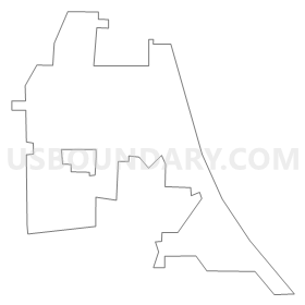
Outline
Summary
| Unique Area Identifier | 583930 |
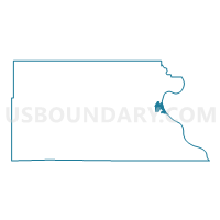
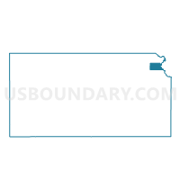
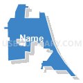
| Name | Atchison Precinct 4 |
| County | Atchison County |
| State | Kansas |
| Area (square miles) | 1.52 |
| Land Area (square miles) | 1.35 |
| Water Area (square miles) | 0.17 |
| % of Land Area | 88.70 |
| % of Water Area | 11.30 |
| Latitude of the Internal Point | 39.54260520 |
| Longtitude of the Internal Point | -95.11780430 |
Maps

Graphs
Select a template below for downloading or customizing gragh for Atchison Precinct 4, Atchison County, Kansas


Neighbors
Neighoring Voting District (by Name) Neighboring Voting District on the Map
- Voting District 16-G, Buchanan County, MO
- Atchison Precinct 1, Atchison County, KS
- Atchison Precinct 5 South, Atchison County, KS
- Lakeview 20 Voting District, Platte County, MO
- Mount Pleasant Voting District Township, Atchison County, KS
- Shannon Township Voting District, Atchison County, KS
- Walnut Township Voting District, Atchison County, KS
- Walnut Township Enclave Voting District, Atchison County, KS
Top 10 Neighboring County Subdivision (by Population) Neighboring County Subdivision on the Map
- Atchison city, Atchison County, KS (11,021)
- Shannon township, Atchison County, KS (1,282)
- Rush township, Buchanan County, MO (892)
- Mount Pleasant township, Atchison County, KS (864)
- Marshall township, Platte County, MO (716)
- Walnut township, Atchison County, KS (441)
Top 10 Neighboring Place (by Population) Neighboring Place on the Map
Top 10 Neighboring Unified School District (by Population) Neighboring Unified School District on the Map
- Atchison Public Schools Unified School District 409, KS (12,435)
- West Platte County R-II School District, MO (3,822)
- Buchanan County R-IV School District, MO (2,123)
Top 10 Neighboring State Legislative District Lower Chamber (by Population) Neighboring State Legislative District Lower Chamber on the Map
- State House District 29, MO (35,957)
- State House District 63, KS (22,789)
- State House District 40, KS (20,957)
Top 10 Neighboring State Legislative District Upper Chamber (by Population) Neighboring State Legislative District Upper Chamber on the Map
Top 10 Neighboring 111th Congressional District (by Population) Neighboring 111th Congressional District on the Map
Top 10 Neighboring Census Tract (by Population) Neighboring Census Tract on the Map
- Census Tract 816, Atchison County, KS (4,488)
- Census Tract 307, Platte County, MO (3,382)
- Census Tract 29, Buchanan County, MO (3,250)
- Census Tract 818, Atchison County, KS (2,907)